Monday, August 25, 2008

Katmai Caldera

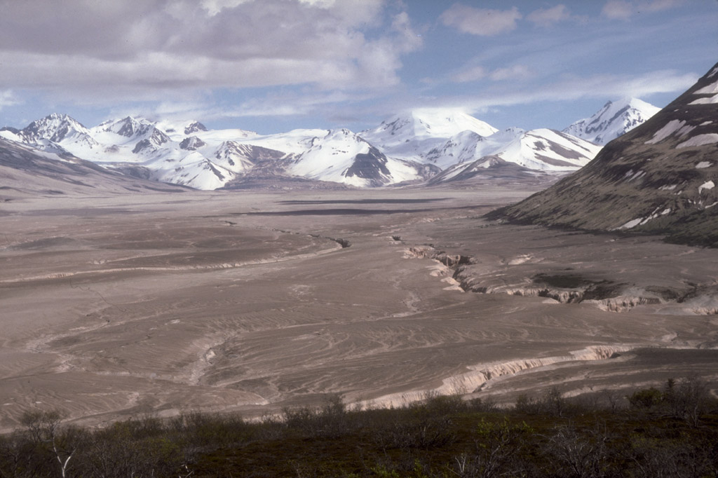
I got back yesterday from my solo ascent of Katmai Caldera. Katmai Caldera was formed as a result of the largest volcanic eruption on earth since 1884. During that 1912 eruption Mt. Katmai collapsed forming a 2 mile wide crater lake in a caldera where there had previously been a mountaintop. That eruption also formed the massive ash-covered Valley of 10,000 Smokes, where we offer daily tours via a 23-mile bus ride from Brooks Camp. Most people only go there for the day and see the view from our overlook cabin, but you can get dropped off and backpack out there and see the actual volcano, Novarupta, as well as a host of other volcanoes like Mt. Katmai and its crater lake. The above link (you should zoom in) shows the view from the overlook, the start of my hike. At the far end there is the dirty foot of a glacier leading up to a snowy concave horizon - that is my destination, 20 miles away. Well I hiked there on my 3 day weekend, and all I can say is that it was one of the most awesome things I have ever done in my life. I had the best weather I have ever seen in the Valley - sunny and not a cloud in sight. I made it out to the Baked Mountain huts on my friday (actually sunday) night. The Baked Mountain huts are some old dilapidated shacks in the middle of the Valley put there in the 50s by USGS, and is currently used as a convenient base camp due to its central location to explore the Valley. You might remember it from my blog last year. It is a 12 mile hike to the Baked Mountain huts, with 2 river crossings that I did in exactly 4 hours, with a 40 pound pack. That is fast. I wanted to do that so I would have 2 possible days to make the caldera, in case the weather was bad one day. A lot of times people have to turn back because the clouds are too low, but that wasn't a problem this weekend.

The next day (1st day of my 3 day weekend) I hiked to the Caldera and back - around 18 or 20 miles. The scenery is beyond description. A few miles from the shacks, what is left of Mt Katmai comes into view. There are 3 enormous glaciers that spill off of it and end in giant muddy feet, and across one of those feet and straight up the side of a snowwhite mountain you can see where the rim of the caldera would be. It is an incredible feeling to take a look at that landscape, see your destination 7 miles away and 3500 feet up, guarded from you by glaciers, snowfields, crevasses, and innumerable smaller hills and peaks, and then start walking that way alone. I had no idea when I started out if I would be able to do it but I decided to give it a shot. My buddy loaned me his cramp-ons and iceax, but I hardly needed them as the snowpack was still firm and good for walking. Coming over the last slope up to the rim, at 5500 feet above sea level, that first glimpse of the crater lake was breathtaking. A crystal bluegreen lake, massive, a few hundred feet below you. Like in a bowl with jagged mountain peaks for its rim. Thinking about it makes me regret, for the first time this summer, not having a camera. I tend to believe that my own memory offers a more true representations of the things I have done in my life than photographs, but in this case I wish I could send you some pictures. Here is one that that my friends Ralph and Greg took last year. The first shows part of the route up to the caldera. The snowy lip at the top is the rim. It was a much clearer day when I climbed it.


The second is a picture of the crater lake itself.


Here is an aerial view of the Caldera, which may be the best way to understand its scale.

The route that looked the easiest was to hike through a higher saddle between two peaks and then drop back onto the main glacier for the final push to the rim, and on that saddle before I dropped back down I got an added bonus. I could see the coast! Katmai Bay 20 miles to the south! Through my binoculars I could see the wide braided floodplain of Katmai River feeding out to the ocean, and waves lapping in on the shore. And in the distance, what I thought at first were distant clouds, was actually a range of jagged mountains - Kodiak Island, over 120 miles away. Imagine my feeling - I had always wanted to climb somewhere to see the coast, and I had no idea that this trip would put me in view of it. On the way back, I climbed the small hill whose saddle I was walking through and from there, I could see in a panoramic view the Pacific coast and Kodiak on one side and all the way 45 miles back to Brooks Lake and Naknek Lake (where I sit now typing this journal) on the other. Here is a good satellite image of the Valley, you can see my route - I started at the west end of Windy Creek, camped at Baked Mountain, then went to the Caldera and back. You can also see the Pacific Coast and Katmai Bay that I caught a glimpse of. It was a 12 hour hike that day, and when I finally made it back to Baked Mountain even a foam pad on a plywood bunk gave me pleasant dreams.

Sunday, August 12, 2007

My Mom Caught a 32-inch Rainbow Trout

That's right. If that statement does not immediately blow your mind, go ahead and google "record rainbow trout" and get back to me. Of course, you don't catch a fish like that without an expert guide and captain, which was This Guy. We caught him trolling off a shelf in the Bay of Islands in Naknek Lake.


My parents visited here for a week and had the time of their lives. We also caught a bunch of Arctic Char in Margot Creek, and of course some sockeye salmon right here at Brooks River. My mom hiked up Mt. Dumpling on a beautiful day and got a bird's eye view of Brooks River. It's too bad we didn't take a good picture of the trout, now no one will believe us. The pictures we have don't have a point of reference so you can't tell how big it really is. But we measured it, 32 inches, and it was fat as hell too. Put it this way; it was way bigger than the biggest sockeye I have caught. It was huge.

Just for fun, here is a picture of me at Halloween dressed up as the guy who got drunk and chased bears through the river (see previous comments). Note that my coworker Greg looks way too much like me.


That's all for now catch y'all later. If anyone can send me a tape of the Jags first game, or the upcoming ones, let me know.

Thursday, July 19, 2007

Clever Girl

I put up a post talking about what the falls looked like before the salmon arrived, but I never put the picture up. Here is what the falls looked like when I first got here.


To quote myself, "For now Brooks Falls is just a small waterfall on a mile-long river, and standing there it is hard to believe that such a seemingly insignificant place is the basis for the health of an entire ecosystem, the survival of a community of brown bears, the strength of a regional economy, and the spiritual fulfillment of thousands of people."

Well folks, it's not so hard to believe anymore.


And here's what it looks like if you step back a bit:


There you have it, the reverse-zoo of the Brooks Falls River Platform. Here's another shot from the downriver Riffles Platform, looking up at the falls.

More on the bears later; I have a few more pictures to share. The other day I went out fishing in Naknek Lake, and I wasn't having any luck so I traded my pole for my camera so you could see the kind of views I get here while waiting to hook a salmon.

Here is another great view; I took this photo of Brooks Lake right before I set out in a boat to Headwaters Creek at the other end of it to fish sockeye.

I took these from the same spot later that day. Follow the eagle -- he starts in front of Dumpling Mountain...


And 27 seconds and 180 degrees later he is in front of Mt. Kelez.


Working the corner, a wooded spot where bears frequently pop out right next to you, can be an exciting affair. But I often ponder what it would be like if brown bears were not the solitary creatures that they are, and learned to hunt in packs. I call this my "Jurassic Park Theory"; imagine a group of photographers gawking over a gorgeous blond bear in the distance, when all of a sudden the bears that have been stalking them all along ambush from the sides... Fortunately for us (or unfortunately depending on how much you like photographers) bears are not velociraptors. A spring cub with a protruding tongue seems intent on reminding me of this:

Friday, July 13, 2007

Bay of Islands

Sorry I haven't had the time to write an entry lately. Things are getting pretty crazy around here; lots of people and lots of bears. It might be impossible to describe the situation at Brooks Camp with mere words and pictures. Would you believe me if I said that this morning I had to put my waders on to cross the river because there were 8 bears within 50 yards of the bridge? How about if I told you that two minutes later, on my way to Brooks Lake to go fishing, I had to back off the trail to allow a mother brown bear with a cub to pass within about 20 feet of me? And if I said that as I was backing up, I allowed myself a calmer look at this sow and cub and realized I knew their names? Does it sound unbelievable when I returned tonight from Brooks Lake tonight, I actually was able to cross the bridge -- after the spring cub that had climbed onto it managed to find his way back to his mother and sibling, and after they and the other sow with her three 3-year-old cubs moved off? Right now I am using a computer in the ranger station; it's 1:00 in the AM and actually dark here. Imes popped in 5 minutes ago to tell me to be careful, he just saw the rear end of a large bear walking through camp. My roommate just came in and said when he opened the door of our cabin, there was a bear right in front of him. I am starting to wish I had brought a flashlight.

But there will be plenty of time to talk about Brooks River and its remarkable and hairy inhabitants. As you know, Brooks Camp is just a tiny dot on the map of a 4.7 million acre park that includes hundreds of miles of coastline, a stretch of the Aleutian mountain range containing 5 active volcanoes, the second biggest lake in Alaska, and the valley where the largest volcanic eruption of the 20th century took place. I have decided that I am going to try and see as much of this incredible park as I can while I am here, and so last weekend I ventured to the North Arm of that aforementioned lake to a spot called the Bay of Islands.

I had run across some pictures of the Bay of Islands on one of our computers and decided I would like to go there. As it turns out, the Park Service has a backcountry cabin in the bay that can be reserved and somehow I was lucky enough for it to be open on my day off. So Ralph (a ranger from Savannah) and I took off bright and early in one of our boats loaded up with a couple kayaks so we could do some exploring once we got there.

In hindsight I should have taken a more pirate-like approach but at the time coffee seemed more appropriate than rum. It was an hour long ride around the corner of Mt La Gorce (link to map above) to get to the Bay of Islands, and as we got into the bay I was amazed at how a short boat ride could bring us to a wilderness so unique from the one we left at Brooks Camp. Here are those pictures had seen on our computer; they are an aerial view of the Bay and do the best job of acquainting you with the landscape:


As you can see, the Bay of Islands is a valley where the water level has risen to create a bunch of small wooded islands -- a great place to explore, camp, or fish. It has been described as the Everglades or Keys of Katmai, and I definitely got that feeling as I was kayaking around. There were some marshy areas that definitely reminded me a canoeing in Florida, if not for the huge mountains in the background.


Fure's Cabin is located a the end of the bay, in a small cleared area on the thickly forested shore. It was built by a trapper in the 1920s before that land was part of a National Park, and technically Roy Fure was trespassing from after 1931 when his land was incorporated into Katmai. He continued to live there anyway, and today the NPS maintains the cabin for visitors to stay at; you only have to reserve it (usually far in advance) and find a way to get there (boat or floatplane). Its red roof guided our approach from afar.


The cabin was cozy and clean, and you cant beat the panoramic view... (click for a bigger picture)

We dropped off our stuff at the cabin and set out in the kayaks to explore the nearby islands. They had mostly rocky shores, but I stopped at a few sandy beaches and was surprised to find bear and moose tracks at all of them. There isn't exactly a great food source on these small islands, unless you consider a white-crowned sparrow a hearty meal, so I wondered why a bear would take the time to swim across a huge lake to get to an small island without food. Maybe he was just passing through on the way to the salmon at Idavain Creek and decided he would swing over to a couple of islands to explore and claim them for his own. Maybe he caught a whiff of a good smell and decided to go check it out. What about the bears that beheld the islands with curiosity but decided to carry on with more important tasks? Either way, it must feel nice just to be faced with such a dilemma. The thought of such a wild and unconstrained choice makes me reconsider my notions of freedom.

As I paddled, I didn't see any bear or moose, only their tracks, but I did see some other fascinating wildlife that I have never seen before. Take a look: a goldeneye and some common loons.


Fure's Cabin has a wood stove for heat and cooking, so after kayaking around most of the day I set out that evening to do some fishing. I wasn't out there 30 minutes before I pulled up to the side of the boat the biggest trout I have ever seen in my life; a salmon-sized lake trout, 28 inches at least, fat all around. When I saw it came to the surface "oh my god" was all I could think of to say to myself. I reached over to grab it through the mouth to lift it into the boat, but for some still inexplicable reason I lifted it by the line, which of course broke. I watched that monster, our dinner, swim away slowly and disappear back into the depths. It is moments like these that make grown men cry. Somewhere in the Bay of Islands a massive lake trout is lurking on a sandy shelf, my neon green spinner proudly displayed in the side of his mouth. I should offer a reward.

Believe it or not, fishing takes on an entirely different feeling when you are really counting on it for food. I wasn't going to starve that night inside Fure's Cabin, but that lake trout would have been a hell of a lot better than the peanut butter and crackers I ended up eating. It was the thought of those crackers that kept me fishing for 3 more hours after I lost that monster laker, but to no avail. It was one of the few times I have been shutout since being in Alaska. From his vantage point back at the cabin, Ralph did not yet know I was returning empty handed.

After our disappointing dinner, we decided to take the trail from Fure's to Lake Grosvenor. This trail is part of the Savonoski Loop, an 86 mile canoe/kayak loop that takes you from Brooks Camp up through the Bay of Islands, down Lake Grosvenor into the Savonoski River, and back into the Iliuk Arm of Naknek Lake and to Camp. The only part on land is a 1.5 mile portage between Fure's Cabin and Lake Grosvenor, and as I walked it late that night I was glad I wasn't carrying a kayak. It was dark by the time we got to Grosvenor, but Ralph managed to get this good picture using some camera trickery, and it seems like a good way to say goodnight.